
The avalanche report is a great place to find unbiased information about the snow conditions and the weather forecast. Obviously it should always be the first port of call before a trip off piste too. It’s updated at 4pm each day. So it’s ready to be checked the night before a trip out. The forecast is made by real people using real observations and not by a computer model that is taking a guess!
There is a separate forecast for each region. I’m concerned with the Haute Savoie, AKA the Alpes du Nord. It’s all accessible from the following link.
http://www.meteofrance.com/previsions-meteo-montagne/bulletin-avalanches
Here I will deconstruct the forecast for tomorrow. Wednesday February 8th 2017.
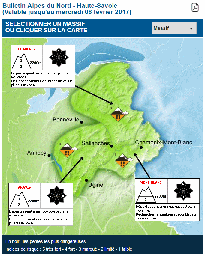
You can see the region is split into 3 areas. The Chablais, Mont Blanc and the Aravis. I’ll choose the Chablais because that is where I live. Tomorrow you can see the risk of avalanche is 3 (marqué), this translates as “considerable”. This is the level at which most people get hurt! When it gets to 4 (fort / high) or 5 (trés fort / extreme) skiers tend to worry more and take conservative decisions.
- To be more precise its level 3 at over 2200m metres and level 2 under that height. So basically it’s 2 in 95% of the Chablais. The flag for 3 will fly in the resorts though.
- There is also an avalanche “rose”, that’s the compass symbol. This attempts to let you know if there is more risk on one side or other of the mountain. This often happens because the danger will depend on the wind direction on the preceding days. In this case the risk is the same on all aspects.
- Finally there is a short description of the hazard. So in this case some small to medium avalanche might release spontaneously. Whereas a skier could release anything. This is important because skiers are generally buried in avalanches they have released themselves.
The next stage is to click on the area that concerns you to get the forecast in detail.
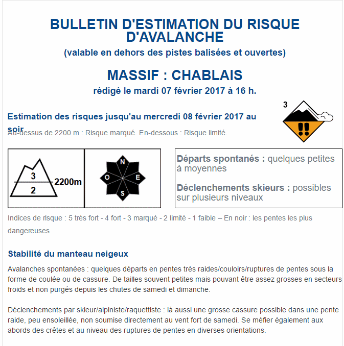
Here there is more detail on the stability of the snow cover.
- Spontaneous avalanches: some releases are possible on the very steep slopes/couloirs/changes of slope in the form of a flow or a crack (slab). The size of these avalanches will often be small but could become quite large in the cold areas that have not yet slipped since the snowfall on the weekend.
- Skier released avalanches: A big crack (slab) is possible on the less steep slopes, not sunny, and not effected by the strong wind on Saturday. Be careful on the ridges and changes of slope angle in various aspects.
That is a bit of a mouthful. Worry not, the next bits have more pictures.
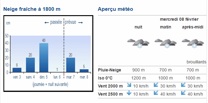
On these images you can see the actual amounts of snow that fell at 1800m and the forecast amounts. Also the weather forecast for Wednesday, it looks to me like light snow all day, the rain/snow line is starting at 900m and dropping to 700m. The wind starts out from the NW and then strengthens from the NE. Wrap up warm, that’s a windchill of less than -10C!
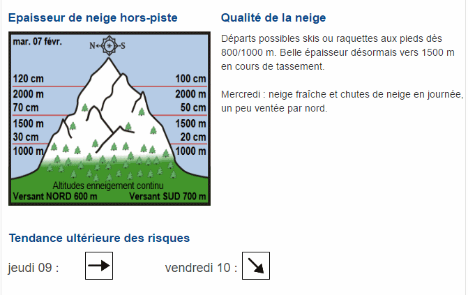
- Here is a pictorial representation of the snow depths on the north and south side of the mountain. You can put your skis on around 800/1000m, once you get to 1500m there is a really decent depth of snow which is starting to settle. Tomorrow you can expect fresh snow all day and a bit of a north wind.
- The “tendance” is always interesting, here they predict the risk will remain the same on Thursday and drop (become safer) on Friday.
The next bit of the avalanche forecast is new. It gives the history over the last 6 days. You can see how it was warm last week and has cooled off a bit since then. It also charts in blue the rain/snow line and how it has fluctuated as the two fronts came through.
The second chart shows the wind speed and direction. You can see that on Saturday the resorts had 100km/hr winds over the tops. Anyone skiing that day will confirm that 90% of the lifts were shut! It’s significant from a avalanche point of view though, these winds will have built up accumulations of snow on the lee (sheltered) slopes, in this case a SW wind…means slabs on the NE slopes.
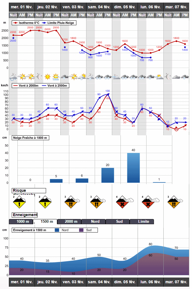
The final charts are self explanatory. Showing the evolution of the avalanche risk and the snow depths.
So there you have it. The avalanche report. A mine of information.

