Tag Archives: st jean d’aulps

Torrent de Boue: Mudslide in Saint-Jean-d’Aulps

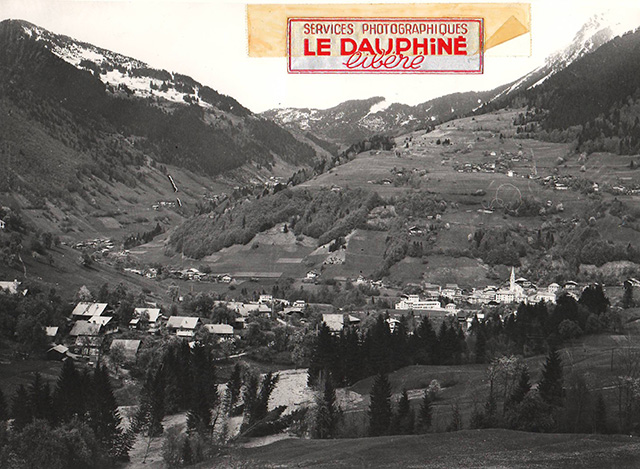
Not far from Lac Léman, in the heart of the Chablais, lies the village of Saint-Jean-d’Aulps. Today, it’s best known for its proximity to the ski resorts of Morzine and Avoriaz — but in 1966, a mudslide slid down through the valley, leaving a lasting mark on both the landscape and those who witnessed it. What follows is a little history, and a reminder that for those who live in the mountains, nature always has the final say.

Photo: Le Dauphiné Libéré Archives – Inondation à St Jean d’Aulps 1966

The Blue Zone

When we bought our house in Saint-Jean-d’Aulps 23 years ago, the notaire informed us it was in a “blue zone,” an area at risk of natural disasters. At the time, I didn’t inquire further, as my wife was expecting our first child (Jacques was born the next day), and I was focused on finalising the purchase of our new home. I initially assumed the risk was from avalanches, given the 900m mountain rising above our house. I reasoned that any such risk had likely passed; before the First World War, the hillside had been cleared for grazing, but since then, the farmers had largely abandoned the land, and the hillside had reforested. In my view, avalanches couldn’t originate in a dense forest.

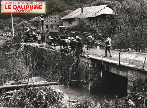
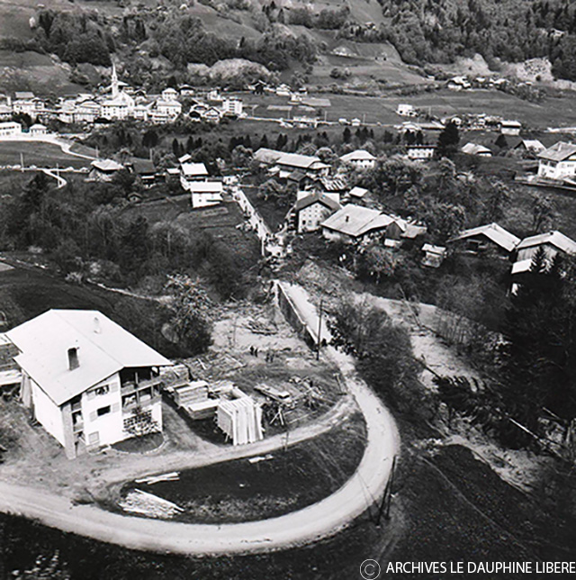
Shortly after moving in, our neighbour, Mr Huneau, introduced himself. While not originally from the area, he had been the principal of the local school 20 years prior, making him well-known in the valley. He asked if I was aware of the historic flood and pointed to the river 200m below our house. He explained that a mudslide had occurred further up the valley, travelled down the river, and blocked the bridge not far from us, forming a lake that had engulfed part of our land. It was difficult to visualise what he described, so I didn’t dwell on it.

Photo: Le Dauphiné Libéré Archives
Photo: Le Dauphiné Libéré Archives -Le Jourdil

The 1966 Mudslide

It is now 2025, and the natural disaster Mr Huneau described happened at the beginning of May 1966, nearly 59 years ago. Over the years, I’ve heard accounts of this incident from various locals. Recently, one of them shared a series of photographs taken by the local newspaper, Le Dauphiné Libéré, at the time. They have given me permission to publish some of them here.

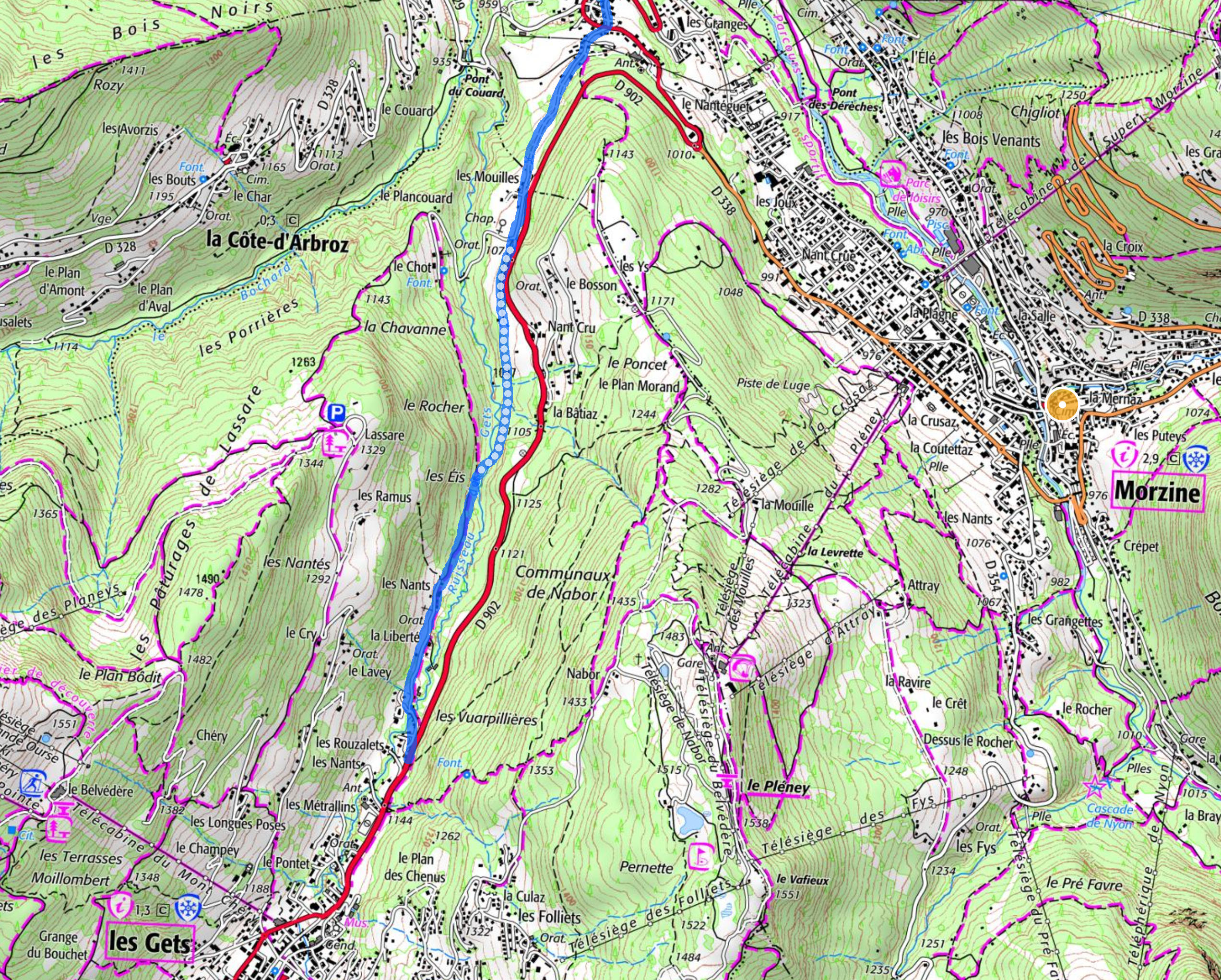
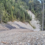
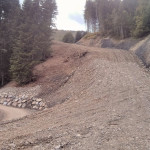
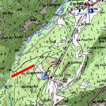
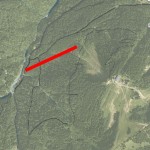
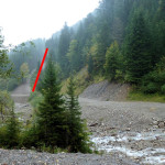
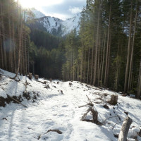
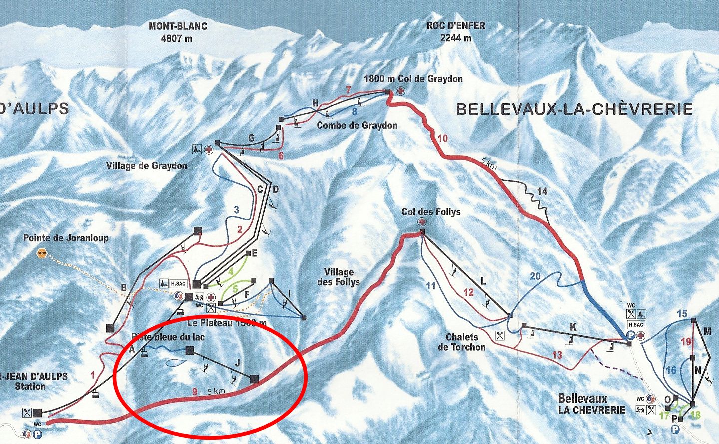
The scar left by the original landslide is visible when skiing the Saint-Jean-d’Aulps ski circuit. It’s on the left as you pass the Restaurant des Follys, and it’s marked on the IGN map as Le Covagny.

Flooding in April and May is not uncommon here. Wet periods combined with snowmelt can lead to such events. In this case, the river has carved a steep-sided valley, the terrain becomes waterlogged, and this can trigger a slide. As a walking guide trained in the region’s geology, the more I learn, the more concerned I become. Much of the local “bedrock” has a layered appearance, with layers of limestone and shale prone to sliding, similar to avalanches. This is called Flysch, a term not particularly helpful unless you’re a geologist. There’s also an abundance of clay, deposited in these valleys when they were flooded and formed a lake at the end of the last glacial period, 20,000 years ago. Add water, and you have an unstable combination.

Photo: Le Dauphiné Libéré Archives – Pont aux Mouilles

Lac de Vallon / Bellevaux

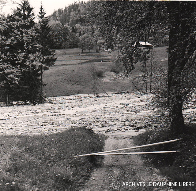
From what I’ve heard and read, the landslide occurred gradually, with a mass of mud and silt moving down the river, sweeping away smaller bridges and trees. When it reached the larger bridge in Le Jourdil, it became stuck, causing a mud lake to back up the valley. A similar event occurred 20 years prior (1943) on the other side of the Col des Follys, only 4 km away. That landslide created a new lake, Lac de Vallon, which still exists today. It is not a big leap to imagine that the same geological and meteorological conditions existed to cause that landslide.

Dynamiting the Gorges des Tines

The local authorities were worried that if the bridge at Le Jourdil was breached the slide would have continued down the valley to the Dranse. The next constriction in its path is the gorge the river flows through at the Tunnel des Tines. Apparently, the army was called in to survey the possibility of mining this gap to blow up the gorge. The constriction the Dranse passes through is only a few metres across and if this is blocked the damage to Saint-Jean-d’Aulps would become significant.

Photo: Le Dauphiné Libéré Archives – Le Jourdil

Nature Always Wins

This incident serves as a reminder that gravity and weather will eventually cause mountains to fall downhill, and those who live among them risk becoming a witness to the process.

If you are interested in what risks you may face in your French property, you can go to this handy website.

https://www.georisques.gouv.fr

Nowadays when you are browsing the web for a property in France, there will be a link to this website to forewarn you of the risks. When I put in my address apparently the risks we face are flooding, earthquake, landslip and avalanche!

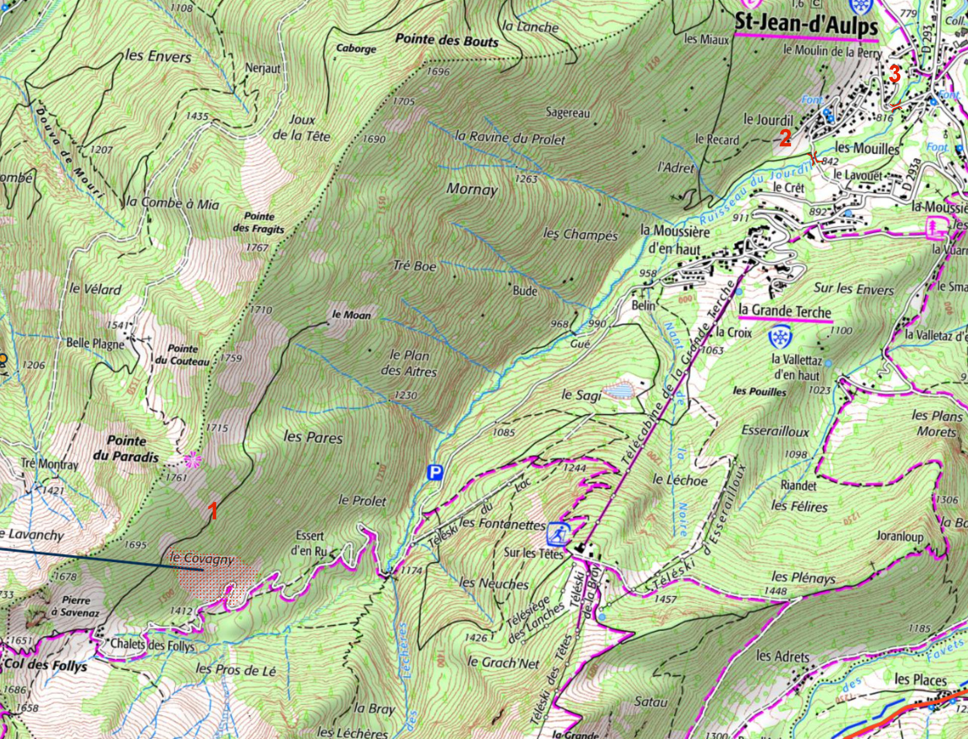
  1. Le Covagny, the site of the landslide is visible on the IGN map
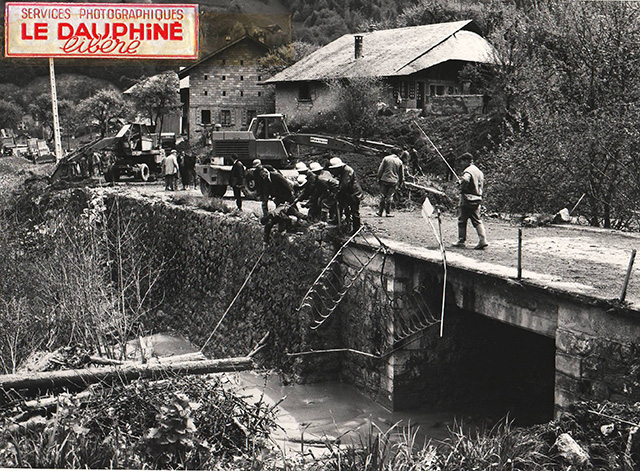
  2. The bridge at Les Mouilles
  3. The bridge at Le Jourdil

Cycle paths in the Alps (or the lack of them)

#See the note at the bottom, it seems the council has been listening to my dreams!

I’m not talking about mountain bike tracks here. I’m talking about transport. At the moment cyclists mostly share the alpine roads with motor vehicles. On the mountain cols that can work OK. Unfortunately, as the valley roads get busier and busier tensions between the two communities rise. And before I polarise this discussion, it should be remembered that almost all the cyclists drive cars too! And some of the drivers ride bikes. So these two communities are really one community.

Between Morzine and Les Gets, my dream, nothing more at the moment © Please do not reproduce this image!

We see all the new investment being spent on skiing, on snowmaking, ski-lifts, new pistes. Not forgetting the new buildings, chalets and apartments. It’s easy to see the link between investment and return. This is not a criticism, I understand the business. We are used to seeing money being spent on new tarmac, new roads, bridges, tunnels. We don’t question this necessity. But I think we are missing a trick.

Between Morzine and Les Gets, the solid blue line exists as a gravel track. The rest is just a suggestion.

We all rely on the mountains to “provide”, we know that they offer more than just skiing. I came here 20 years ago looking for mountains (not skiing). Skiing provided the industry to pay the bills. At that time I was in the minority. Now it’s normal. Now the majority come to these valleys for the mountains. They might ski but they will also bike, run, swim, climb…the list is long. There needs to be a change of emphasis in investment to reflect this.

Cycle paths

I don’t need to state that more people are cycling on the alpine roads. It’s obvious. Many, many times more than 20 years ago. And now we have e-bikes too. Yet another explosion, and this is just the start. All across Europe, there is fantastic cycling infrastructure being created. If you have never been to the Netherlands on a bike, I recommend it. It’s another world. Even closer to home, just the other side of Lac Leman you never have to ride on a busy road. Almost no expense has been spared to keep powered and non-powered transport separate.

Wooden cycle bridge
Pont Rotary on route 5 in Switzerland, for walkers, bikes, roller skis or skates!

But it’s not just in Switzerland. France is catching up too. Near us is the mighty ViaRhona, 815km from Lake Geneva (Lac Léman) to the Mediterranean. There is still work to do around Lac Léman, but the section I rode this summer from Geneva to Lyon was either on smooth cycle tracks like the one pictured below or quiet side roads.

Pont du Lit au Roi on the Via Rhona cyle track, pretty much the “middle of nowhere”.

The bridge in the next image is due to be finished by the end of the year. Again, on the ViaRhona, it’s an investment of 1.8m€ so the cyclists can avoid a busy road. More information here https://www.savoie.fr/entre-la-balme-et-virignin and a reportage here https://www.youtube.com/watch?v=bXCBQJwI9DI

A 170m bridge being constructed on the Via Rhona

At a departmental level there is progress being made. From Chamonix to Geneva the Véloroute Léman Mont-Blanc is progressing well. The Tour du Lac d’Annecy and Annecy to Thones too. There is more information on this dedicated website. http://veloenhautesavoie.com/plan-departemental-74-velo-voies-vertes/

The cycle tracks under construction in the Haute Savoie.

It’s not just national infrastructure either. In the Abondance valley the local municipalities have got together and linked the quiet roads from one end of the valley to the other. 20km in all. An excellent job.

Le Chemin des Bords de Dranse

It wasn’t all easy. This section of raised route clings to the side of the river valley, to avoid the main road on the other side. Unfortunately, it is not a route that is likely to attract the dedicated road cyclist. To do that it would have to have a smoother surface.

However, it is at the Municipal level that progress is much slower. There is so much more work to be done, and some very particular “pinch points”. One of the worst is from Morzine to Les Gets. Two villages only separated by 5km, but if you are a cyclist it’s a very unpleasant section. People even try and walk it, sometimes with tragic consequences. The first two pictures in this blog illustrate what could be done. It should not have to be a dream. It should be a priority. There are plenty of others. Morzine to St Jean d’Aulps, Samoens to Taninges, I could go on.

This sort of thing should not be an afterthought anymore. Cycle provision should be a priority. It does pay too. If the local municipalities prioritise this sort of infrastructure the visitors will appreciate it as much as the local inhabitants. And that is good business!

# It looks like Morzine and Les Gets municipal councils have mobilised to create something ambitious. Excellent! Have a look at this article for more information! https://c.ledauphine.com/culture-loisirs/2020/10/08/une-voie-verte-pour-securiser-les-cyclistes-entre-les-gets-et-morzine

Ski investment at the Espace Roc d’Enfer

Investment for this year includes groundworks on many of the pistes making them better for skiers at a cost of 130.000€. Snow canons have been added at La Cheverie side from the top of the Graydon chairlift all the way down to La Cheverie itself at a cost of 460.000€. A new drag lift called ‘teleski du lac’ is being built to bring skiers up from the Roc d’Enfer circuit allowing them to easily ski back down to the bubble lift. This is 350m long and is costing 330.000€. There are also plans for a new blue piste in the forest from the top of the bubble lift all the way down to the bottom.
I’ve taken some pictures of the work and plotted the line of the new lift.

and some photos here taken 22nd of December 2013

The latest piste map with the area in question circled.
espace roc d'enfer piste map