Looking for an accurate snow forecast for the Alps? There are many to choose from, all if which give a different view. I am an avid weather watcher and find that using a wide range of tools gives me a pretty good idea of what the weather will be up to. In fact scrap “snow forecast” and swap for “precipitation forecast”, it doesn’t always snow!
The first place I go to is Chamonix Meteo:
http://chamonix-meteo.com/
this forecast is compiled by an amateur forecaster for the Chamonix valley. You’ll find this forecast pinned up in the shops and sometimes Tourist Offices too. Much to the dismay of France Meteo who would prefer the local commerces pay for their weather forecast! This weather forecast is often updated twice a day, sometime around 8am and then again at 6pm. Its got a good English translation too.
Another amateur set-up is Météo Léman, as you might guess from the title, it is good for those of us based in the Chablais and the Jura too. In fact you are as well just subscribing to their Facebook page as they post more updates on there.
http://meteoleman.com/
The next website I head to is Snow Forecast (.com):
http://www.snow-forecast.com/
these guys provide animated maps and also a longer (pay) forecast, I used to pay for this longer forecast but don’t need to any more, thanks to the other websites further down the list. If you read too much into the snow depth numbers you might be disappointed. I find one of the most useful bits of this forecast is the temperature (freezing level) graph. Clearly visible here. This weekend it looks like we will need to wear shorts!
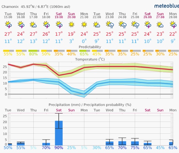
For a longer range forecast I head to MeteoBlue
https://www.meteoblue.com/
this website gives a nice graphical representation of the weather, but as you can see the temperature graph looks quite different from the one above. It’s because they include the diurnal variation, more accurate but less intuitive.
MeteoBlue is full of other useful representations too. This one is on the “14 day” tab. It’s for the same period as the previous screenshots. I think from this we can be sure of a little precipitation on Friday but that the week after there is a 50% chance it will be unsettled (so that doesn’t really tell us much after the weekend).
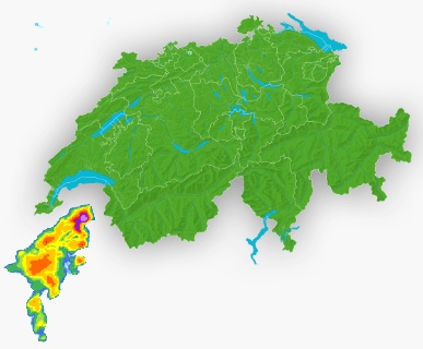
Don’t forget the weather radar either. These give a real time view and predictions for the precipitation over the coming hours. France Meteo and Meteo Swiss are the source of this data. I tend to use the Swiss one:
http://www.meteoswiss.admin.ch
these are only interesting when there is precipitation, not that great as I am writing this. Though it does look like it’s raining over the Ligurian coast of Italy just now.
The Avalanche forecast gives a sober report of the actual snow conditions and an unbiased assessment of snow depth, recent snow falls and a prediction for the next day. This comes out at about 4pm each day with a forecast for the next day, it’s regional too, so for the Haute Savoie it is split into Aravis / Chablais / Mont Blanc.
http://www.meteofrance.com/previsions-meteo-montagne/bulletin-avalanches/
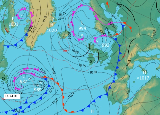
We are getting a bit more in depth here. On MeteoBlue you have access to more than a dozen versions of the forecast. Sometimes you may hear people talk about the Multimodel forecasts, GFS Forecasts, (the wiggly lines), these are the source of all these weather forecasts, basically the various weather forecasting authorities run their mathematical models and these forecasts try and pull them all together. The more the lines follow each other, the more the models agree and the more reliable the forecast. Here is a link to the MeteoBlue Multimodel:
https://www.meteoblue.com/en/weather/forecast/multimodel
Wunderground is an interesting site. It aggregates all the personal weather stations that you can buy and connect to the web. You can’t always trust these have been well sited but the results can be interesting. It’s information like this that means the likes of Apple and Google can now tell you the actual temperature outside via your phone. Quite bizarre but very accurate.
http://www.wunderground.com/personal-weather-station/
More resources.
Snow depths from around the Alps, temperatures and recent snow fall too.
http://metaskirando.camptocamp.org/Nivo.php#Aig
Every link you can imagine on the subject, all the Alps and Switzerland.
http://www.camptocamp.org/articles/107228/fr/liens-utiles-meteo-bulletin-avalanche-neige
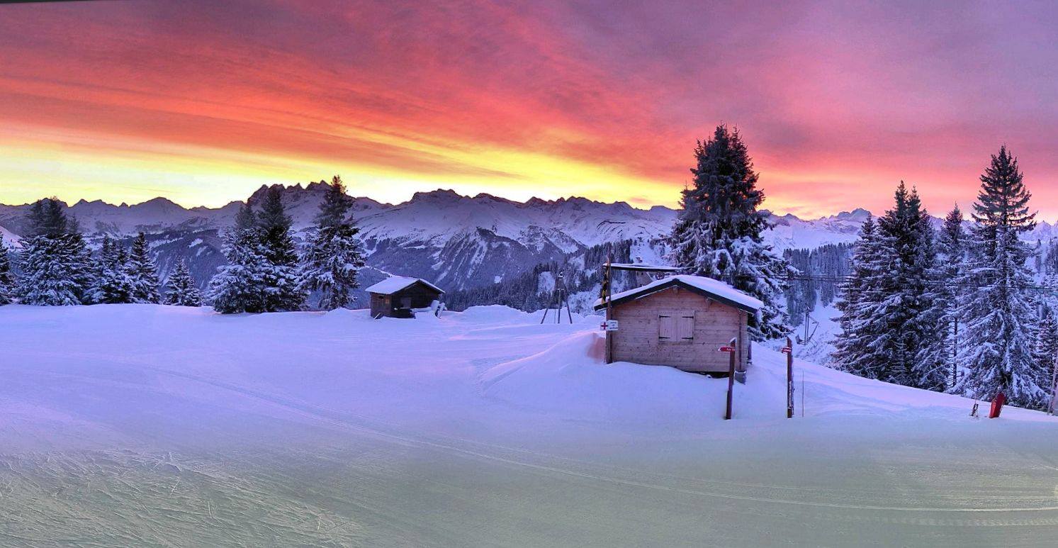
The webcams, of which there are now hundreds to choose from. I’ll include the ones I use for the Portes du Soliel.
Têtes (St Jean d’Aulps, pictured below) http://m.webcam-hd.com/vallee-d-aulps/roc-d-enfer

Pointe des Mossettes http://portesdusoleil.livecam360.net/
Avoriaz http://avoriaz.roundshot.com/
Chavannes (Les Gets) http://m.webcam-hd.com/lesgets/lesgets_chavannes
Mt Chery http://m.webcam-hd.com/lesgets/les_gets_sommet-chery
Lac de Montriond http://m.webcam-hd.com/vallee-d-aulps/lac-montriond
Linderets http://m.webcam-hd.com/vallee-d-aulps/les-lindarets
Plateau St Jean d’Aulps http://m.webcam-hd.com/vallee-d-aulps/plateau-st-jean-d-aulps/